Subsidence
 |
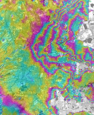
Figure 4.1
Displacement
map of Mexico City metropolitan area for 2000. InSAR and GPS measurements
indicate land subsidence in Mexico City at rates as high as 38 cm/yr,
one of the the highest subsidence rates measured with modern techniques
over a large urban area. Measured rates of subsidence are close to historical
maximum levels of the mid 20th century, when mitigation efforts were first
undertaken to reduce damage to urban infrastructure. However the locus
of maximum subsidence has shifted east from the old city center.
Correlation of our InSAR results with mapped stratigraphic
units and analytical models relating surface subsidence to groundwater
levels indicate that subsidence is primarily controlled by compaction
of Quaternary lacustrine clays and silts. This process represents a major
geologic risk and imposes serious constraints to the maintenance of
its infrastructure and future development of the city. [Cabral et al 2006]
|
4. Subsidence
Many urban areas are subsiding
due to withdrawal of ground water or other fluids (oil, natural gas).For
certain types of aquifer, if the subsidence process goes on long enough,
permanent loss of porosity may result.This means that the acquifer
is permanently damaged, in the sense that it can no longer undergo natural
recharge from surface waters.Figure 4.1 shows in InSAR image of
Mexico City, which is undergoing rapid subsidence due to ground water
withdrawal.Other areas, including parts of New Orleans, are subsiding
due to dessication and oxidation of organic-rich soils that were originally
marsh deposits, subsequently drained to facilitate urban development.
The Geodesy Lab uses a combination
of InSAR, PSInSAR, and GPS to study subsidence. Often, the spatial
and temporal patterns of subsidence may give clues to the nature and
reasons for subsidence, and help mitigate natural (amd man-made) hazard. Our
recent study of New Orleans using PSInSAR [Dixon et al., 2006] showed that certain
levees are subsiding at high rates, possibly contributing to their failure
during Hurricane Katrina on August 29, 2005.
