Mountain Building
Figure 2.1
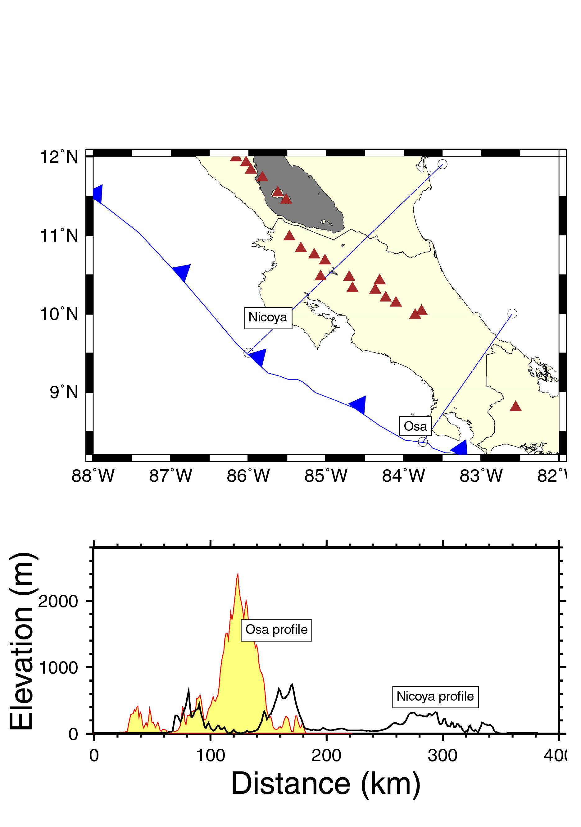
Topographic cross sections for two areas in Costa Rica experiencing active subduction, with the oceanic Cocos plate subducting beneath the western edge of the Caribbean plate (Central America) which includes continental or transitional arc-continental crust. Red triangles are active volcanoes. The northern profile (across the Nicoya Peninsula) shows relatively low topography. Active subduction here has not led to shortening and thickening of the overlying arc-continental crust. The southern profile, across the Osa Peninsula, shows the high topography of the Talamanca Range. Radioactive dating indicates that much of this topography is very young, developed in the last 10 million years. Our GPS studies suggest that this is also a region of high "locking" on the seismogenic zone, providing a possible explanation for the relief of the Talamanca Range. Independent data on crustal thickness is not yet avaialble for this region, which might indicate that high topography is associated with crustal shortening and thickening, similar to the Andes Mountain in South America. From Norabuena et al. [2004].


2. Mountain Building

Mountain building is a fundamental geologic process, responsible for generating continental crust, and many of the mineralogic resources upon which modern society depends. Both of Earth’s major modern mountain belts, the Himalayas and the Andes, essentially represent regions of shortened and thickened continental crust. However, they form in two very different ways. The Himalayas formed by the collision of India with Eurasia, beginning about 40 million years ago. India and Eurasia are both composed of relatively light, buoyant continental crust, which tends not to subduct, hence the shortening and thickening are easy to understand. In contrast, the Andes represent a response to ocean-continent convergence (the Nazca plate underthrusts and subducts beneath South America). In this setting, it is not clear why the western edge of South America has thickened so much (up to 70 km, compared to typical continental crust of 35-40 km thickness). Magmatism is one possibility, although volume estimates suggest that the majority of the high Andes is a response to crustal shortening.

Another suggestion is that Andean crustal shortening is a response to subduction of thickened oceanic crust associated with aseismic ridges on the ocean floor, such as the Carnegie Ridge off Ecuador and the Nazca Ridge off Peru. These features, thought to represent hot spot tracks, are relatively narrow, but might be able to stimulate shortening as they sweep down the leading edge of South America (subduction direction is not generally parallel to the long axis of the ridge).

The Geodesy Lab is conducting research into the mountain building process in several ways. We periodically re-measure a GPS network in Peru and Bolivia in the central Andes. Measurements here suggest that the “back arc” region (up to 1000 km east of the trench) is currently shortening at ~ 10 mm/yr, in approximate agreement with geologic estimates averaged over the last ~ 10 million years [Norabuena et al., 1998]. We also measure the current rate of Nazca-South America convergence, and find that is it slower than the 3 and 10 million year average [Norabuena et al., 1999; Sella et al., 2002]. Numerical modeling suggests that the crustal thickening process reaches a critical point, then begins to slow down convergence via viscous coupling of the deep continental root and the subducting plate [Iaffaldano et al., 2006] in effect limiting the period of rapid mountain building to ~ 5-10 million years.

We also monitor a network in Central America (principally Costa Rica and Nicaragua). Here, convergence between the oceanic Cocos plate and the eastern edge of the Caribbean plate also provide a setting for mountain building analogous to the Andes. However, with one exception, there are no large areas of shortened and thickened continental crust. The exception, in southern Costa Rica’s Osa Peninsula and Talamanca Range, lies inboard of the subducting Cocos Ridge. Here, we may be observing the initiation of the mountain building process, with total shortening across the peninsula exceeding 10 mm/yr [Norabuena et al., 2004].

To the north, the tectonics and present day strain and surface velocity field as measured by GPS are quite different. LaFemina et al. [2002] describe a mechanism for trench-parallel motion of the fore-arc. This is a type of tectonic escape, and may explain why Andean-type crustal shortening is not occurring in this region.