Modeling

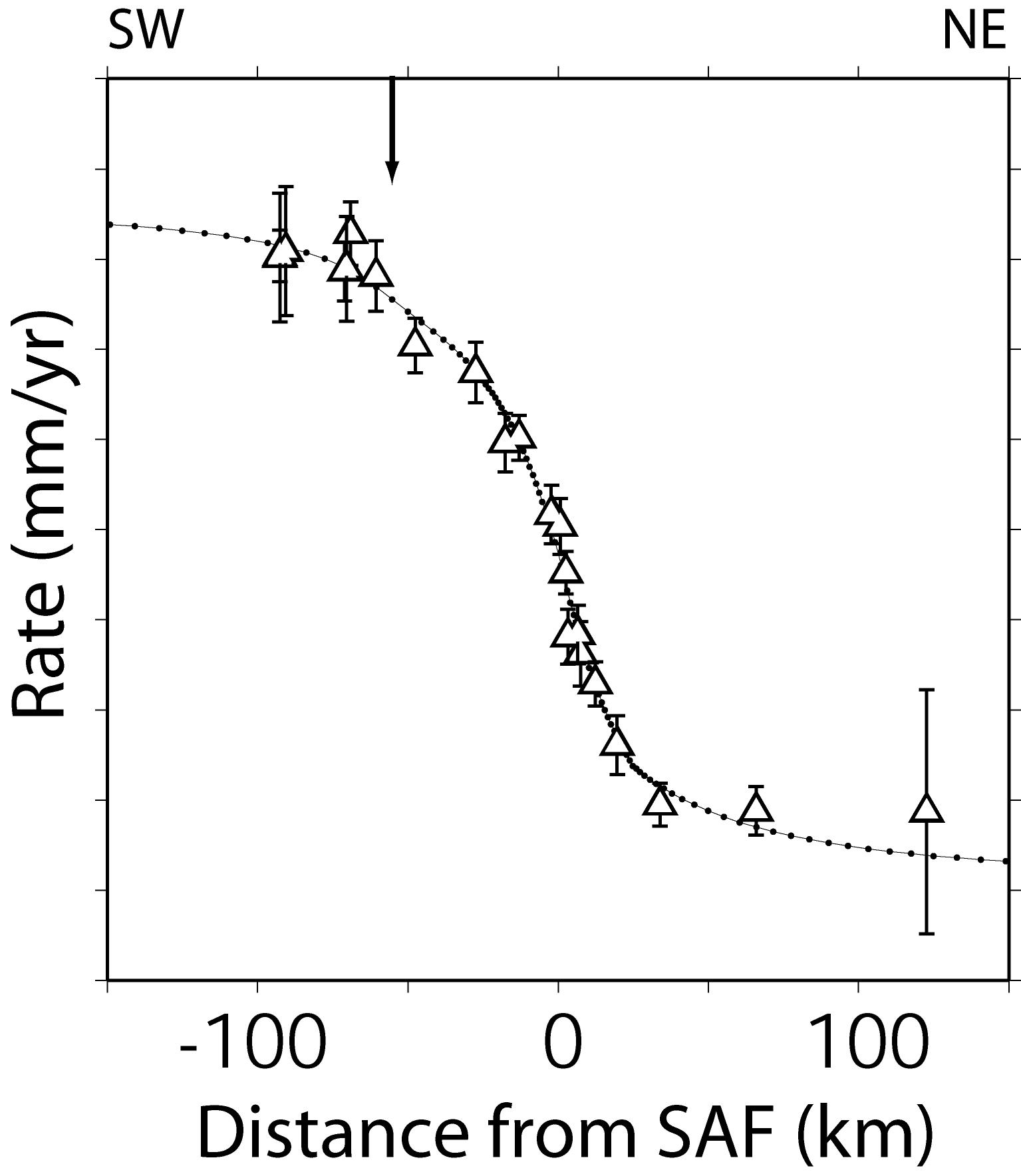
GPS data compared to best fit finite element model, assuming different elastic properties in the upper crust on each side of the fault. Model accounts for strike-slip movement on the Carrizo segment of the SAF (located at 0 km on the horizontal axis) as well as the Los Alamos Fault (at -59 km). The model is consistent with geologic, laboratory, paleoseismic, seismic and magnetotelluric data and is also the minimum misfit solution for the GPS data (chi2 = 9.30, reduced_chi2 = 0.58).   [Schmalze et al 2006]

A standard procedure in most scientific studies is to compare data to a simplified model that captures most of the relevant physics of the problem. In this way we can use the data to test our understanding of the problem. In geodesy, we often assume a simplified rheology for the Earth’s crust and/or upper mantle, and compute the surface displacements that would be observed for a given condition (e.g., slip during and earthquake, or interseismic displacement or velocity associated with a fault’s long term, steady state rate of motion). The computed and observed displacements are compared, and if the fit is poor, one or more parameters of the model are adjusted to improve the fit of the model to the data.  A minimum misfit model then gives an estimate of the optimum value for the adjusted parameters.

A standard rheological model for studying surface deformation associated with faulting, earthquakes, and volcano deformation is the elastic half space model. While this model does not reflect the ductile conditions known to occur at depth, it does a remarkably good job of matching a wide variety of geodetic data, presumably because the surface deformation field is mainly sensitive to the rheology of the upper 10-15 km of the Earth’s crust. In this domain, rock failure occurs mainly by brittle fracture, and at stresses below the failure limit, elastic conditions obtain. Another advantage of elastic half space models is that simple analytical solutions are often available for a variety of deformation sources.

For more complex rheologic models of interest to the geodesist studying Earth deformation, it may be advantageous to use finite element models (FEM).  These models have long been used in the aircraft and motor vehicle industries to study stresses and strains in complex structures. They are also widely used in the Earth Sciences, because they can readily approximate complex rheologies and complex deformation sources. Their major disadvantage is that they may require long computer runs times, although this is becoming less of a problem as computer costs decline and computing speeds increase. For examples of FEM applications to volcano deformation, see Newman et al. [2002] and Newman et al. [2006]. For an example application to the rifting environment, see LaFemina et al. [2005]. For an example of FEM application to strike-slip faulting, see Schmalzle et al. [2006].